Oueme-Survey
UAS hydrometry survey in the Ouémé River, Benin

Fig 1: The Ouémé River in Benin
On Monday, 5th of May, members of the UAWOS team traveled to Benin to conduct UAS and in-situ hydrometry surveys in the Ouémé River. With a length of 500 km from its source in the Atakora Mountains to its mouth in the Gulf of Guinean, the Ouémé River is an essential lifeline in Benin. The cycle of dry and wet seasons shapes life along the river, where the dry and wet periods each bring merits but also limits and hazards to the residents’ population. And life was busy at the Ouémé river, particularly at the Bonou site, where local groups (“communes”) extracted deposited sand the river carried in the wet season, while others specialized on fishery. When the UAWOS team arrived with drones and boats, life was even busier at the Ouémé. But with mutual attentiveness, everyone benefited from each other and the locals’ interest and helpfulness was charming – particularly when our boat broke down in the middle of the stream and immediate support from local shippers was offered.

Fig 2: Life is busy at Bonou
The UAWOS team conducted the survey from 6th to 10th of May – and, thus, in the transition from the dry to the rainy season with neither too little nor too much water flow.
Two sections of the Ouémé river were surveyed: a stretch of around 6 km around the gauging station of Bonou and the region around the Zou inflow at Dasso. Each survey site is subdivided into 10 cross sections (xs).
The drone-based measurements consisted of:
- Orthophotos of both sites, operated by Benin DroneLab
- LiDAR coverage of both sites, operated by Benin DroneLab
- Water surface elevation (WSE) with UAWOS radar altimetry payload
- Velocity with UAWOS Doppler radar payload
- Bed geometry with UAWOS water penetrating radar (WPR) payload
The traditional measurements are conducted:
- Velocity with Ott MF-PRO (2 xs)
- Bed geometry with sonar Deeper chirp+3 (4 xs)
- Water surface elevation from altimetry satellite (SWOT)

Fig 3: M300 with water penetrating radar
In four days, the selected cross sections were surveyed. The experienced UAWOS team faced two new challenges in the Ouémé survey: the remoteness of the sites, particularly the Zou site, and the tropical climate. The flood plains are perennially vegetated, and the cross sections were hard to reach and even harder to get through. The UAWOS team made all necessary preparations and brought essential devices and tools – but didn’t bring a machete via plane to fight through the vegetated flood plains. Instead, the team used a boat to move efficiently and cover as many cross sections as possible. Shipping on the river had thus multiple advantages: the team could move fast, smoothly, and unarmed, and the boat coverage and air breeze offered sun and heat protection.

Fig 4: Move fast, fly high: operating the drone from boat
Traditional measurements were conducted to compare and validate the drone-based data. The team used an ADCP boat (velocity), a sonar (bed geometry), and a MID (Ott-MF Pro, velocity) for the in-situ measurements.

Fig 5: Drone-based and traditional measurements at the Ouémé River
Back in Europe, the data is being processed. The first processing and analysis show nice fits of velocity (Fig 6), bed geometry (Fig 7), and water surface elevation (Fig 8). The drone-based WSE in Figure 8 demonstrates how small features and changes of WSE are adequately capture with LX-80 while satellite-based data, such as SWOT, fails to monitor this level of detail.
The first look at the data is promising. The data will be made public as soon as the processing and quality checks are completed. Overall, the UAWOS team had intense days in Benin. The team travelled back to Europe with a suitcase full of hydrometric data – but also great memories of the special life at the Ouémé River in Benin.
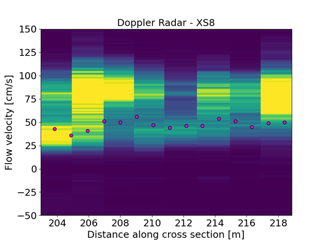
Fig 6: Velocity comparison of drone-based Doppler radar and Ott MF-Pro (purple circles)

Fig 7: Bed geometry comparison of drone-based WPR and sonar (purple circles)

Fig 8: Water surface elevation comparison of drone-based LX-80 and satellite-based SWOT

Fig 9: The UAWOS team examining their next survey site in Benin