First UAWOS Newsletter
UAWOS Newsletter 1
Payloads and Surveying Services
Spring 2025
Welcome
Welcome to the inaugural UAWOS newsletter. We are pleased to have you join our community and share with you the latest developments and findings from our Horizon Europe project on contactless airborne river hydrometry. This newsletter will provide an overview of project activities and results, as well as in-depth information on specific topics, including practical guidance for field procedures. For more information, please visit our website at https://uawos.dtu.dk/, follow us on LinkedIn (#UAWOS), or contact us via email at pbg@ign.ku.dk.
UAWOS Progress Summary
UAWOS has successfully completed its first review cycle with the European Commission. Key achievements from this initial project phase include:
- Developing a drone-borne radar altimetry payload and a surveying workflow for high-resolution water surface elevation monitoring.
- Creating drone-borne echo-sounder and water-penetrating radar payloads, along with a workflow for riverbed elevation mapping, integrating these with lidar surveys.
- Developing a drone-borne Doppler radar payload and surveying workflows for monitoring river flow velocity and river discharge.
- Validating these workflows across diverse river environments in four use cases: the Rönne River (Sweden), Upper Isar River (Germany), Orco/Po Rivers (Italy), and Torne River (Sweden/Finland).
Recent Publications
We're pleased to announce two recent publications showcasing UAWOS research:
Zhou et al. (2024) (https://doi.org/10.1029/2024WR037375): This paper introduces the new UAWOS Doppler radar payload and compares its river surface velocity measurements with various in-situ and airborne techniques. It reveals the influence of both river flow and drone propeller downwash on Doppler signals, representing the first comprehensive demonstration and validation of drone-borne Doppler velocimetry in a riverine environment.
Zhou et al. (2025) (https://doi.org/10.1038/s41597-025-04611-x): This publication documents data formats, metadata, and example datasets from the Rönne River for all UAWOS data types (water surface elevation, riverbed geometry, and flow velocimetry). It also systematically compares UAWOS surveying workflows with alternative in-situ and airborne technologies.
Explore our complete list of UAWOS publications here: https://uawos.dtu.dk/publications.
Data Highlights
UAWOS is committed to open data sharing. Datasets collected across our four use cases—Rönne River, Upper Isar River, Orco/Po Rivers, and Torne River—are available for download in our data repository. Each dataset includes in-situ benchmark data and is provided at three processing levels: Level 1 (raw data), Level 2 (georeferenced point data), and Level 3 (data projected to the river centerline or cross-section). The following examples from the Torne River survey illustrate the comparison between our UAS hydrometry data and ground truth measurements.
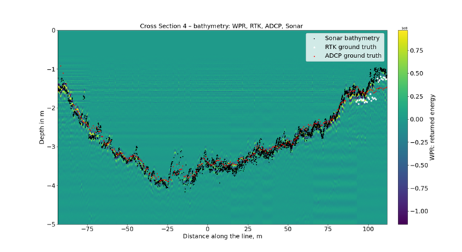
Water penetrating radar and sonar bathymetry for Torne River. Ground truth data from RTK ruler measurements and ADCP are shown for comparison
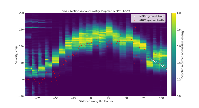
Doppler radar surface velocimetry for Torne River. Ground truth data from OTT MFPro measurements and ADCP are shown for comparison
Upcoming Events
UAWOS is planning an extensive field campaign in 2025, comprising four major surveys:
- Orco River Morphological Change Assessment: A follow-up survey will quantify the morphological changes in the Orco River resulting from the 2024 extreme hydrologic events.
- Ouémé River Hydraulic Modeling Support: A UAS hydrometry survey will acquire essential data for hydraulic model development and flood risk assessment in the region. This survey will be implemented in collaboration with Benin Drone Lab.
- Ogun River Integrated Hydrometry Demonstration: A UAS hydrometry survey will demonstrate the synergistic use of satellite and UAS-derived hydrometry data for improved monitoring in poorly instrumented and remote areas.
- Isar River Extreme Flow Monitoring: A UAS hydrometry survey in the Bad Tölz region will assess the utility of UAS-based measurements for the surveillance and management of extreme flows and flood events.
UAWOS is also co-organizing a session at the upcoming EGU General Assembly: "Advances in river monitoring and modelling, including UAS and satellite based methods". We invite you to join us at EGU to discuss the latest advancements and research in contactless river hydrometry.
20 Centimeters Above: A Drone Pilot's Aquatic Adventure
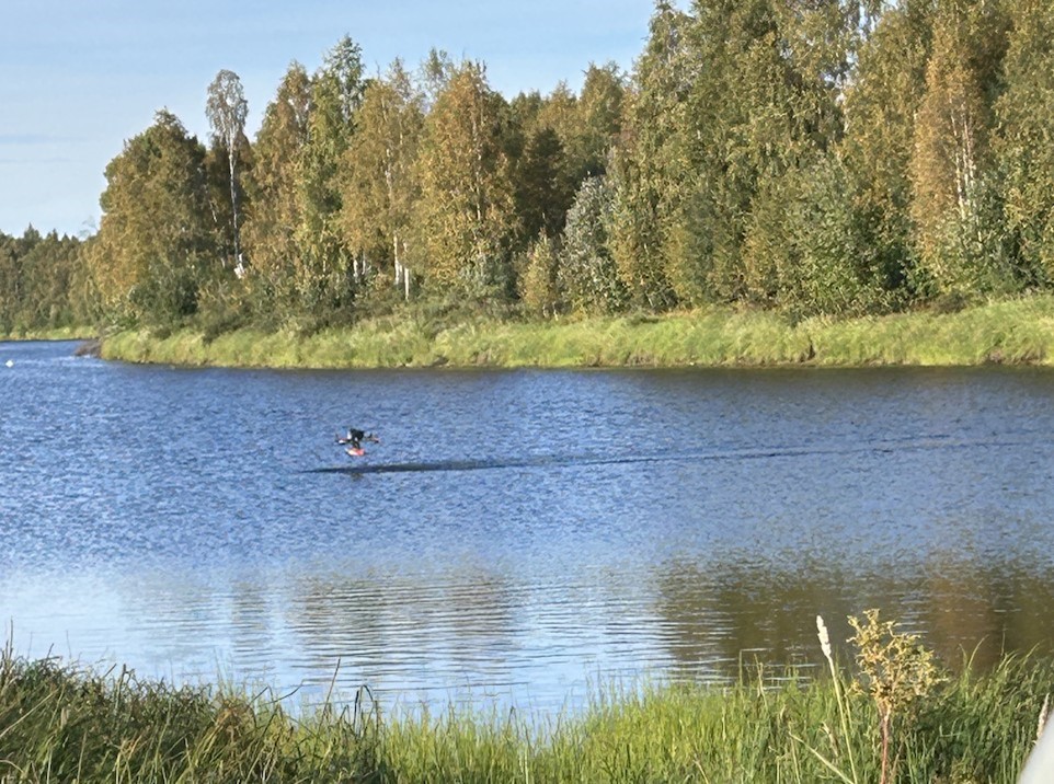
Low-elevation water penetrating radar river bathymetry surveying in the Torne River
Operating low-altitude drone surveys has been a genuinely exhilarating experience. There's a unique thrill in witnessing landscapes unfold from above, all while maintaining precise control over the flight path. Each mission presents its own set of challenges—from navigating unpredictable weather to ensuring seamless operations and maintaining constant situational awareness.
A major highlight has been observing how advanced drone technology captures crucial data, revealing insights that would be virtually unattainable from the ground or shore. It's deeply rewarding to know that each flight contributes meaningfully to the project's objectives.
Flying at such low altitudes over water, however, is a fascinating yet nerve-wracking endeavor. Picture this: our drone hovering just 20 centimeters above the water's surface, hundreds of meters away. The tension was palpable, especially considering the drone's protruding antennas, vulnerable to being clipped by a rogue wave, potentially sending it crashing into the water.
To streamline our deployments, we often parked our vehicle several hundred meters from the river. We'd launch the drone from the car, allowing it to hover while we walked to the water's edge. Once there, we'd guide it down to us, avoiding the arduous task of navigating through dense vegetation. After a quick battery swap, the drone would embark on its pre-programmed mission.
One consistent challenge was the reliance on satellite imagery for our flight routes, which didn't always reflect real-time water levels. This necessitated on-site adjustments, lengthening routes when water levels dropped and shortening them when they rose.
Beyond the technical hurdles, the opportunity to experience these incredible locations firsthand has been truly special. I've had the privilege of participating in surveys in both Italy and the Swedish/Finnish Arctic. It's remarkable to be so immersed in nature and connected with local communities. How often do you get to cross the Arctic Circle or savor the culinary delights of Italy?
Naturally, low-altitude flights come with their share of anxieties. But once the setup was complete, the focus shifted to simply watching the drone soar, absorbing the breathtaking scenery, and engaging with the warm and welcoming people we encountered along the way
Beyond Visual Line of Sight (BVLOS): towards more efficient field campaigns
While drones have extensively contributed to the collection of relevant data for river hydrometry, there are still challenges ahead of us when it comes to field operations. As it has been highlighted in this newsletter, there is still a burden associated with using drones – they must be flown in Visual Line of Sight (VLOS), meaning that the pilot and crew must always be by the water shore to monitor the flight. This is due to regulatory limitations, as well as hardware limitations, since the radio connection between the pilot and the drone (vital for real time control, telemetry, video streaming, etc.) can be affected by obstacles, which often include dense vegetation or man-made structures. Naturally, this has an impact on the duration and efficiency of a drone survey - the pilot and crew must often relocate to comply with the above constraints.
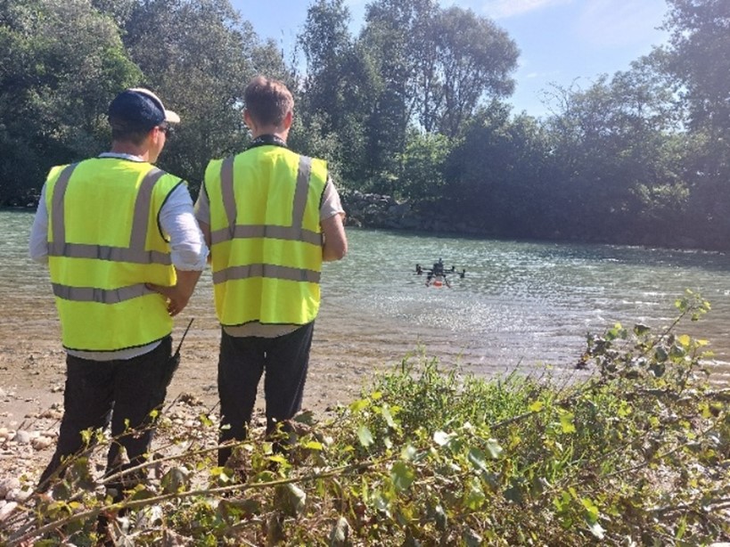
Water penetrating radar survey flight in the Orco River
But what if we could overcome these limitations, and extend the operating range while limiting the number of relocations? This is exactly what we hope to achieve with a Beyond Visual Line of Sight (BVLOS) system. With such a setup, the need for relocations and proximity to the river itself would be limited. This would be achieved by employing a relay drone. Instead of the radio link being transmitted directly from the pilot to the survey drone, an additional drone, hovering at a high altitude, would instead relay this signal. The relay drone would also be equipped with a camera, tracking the survey drone flying low above the water surface, and transmitting this imagery back to the pilot, to adequately monitor the flight.
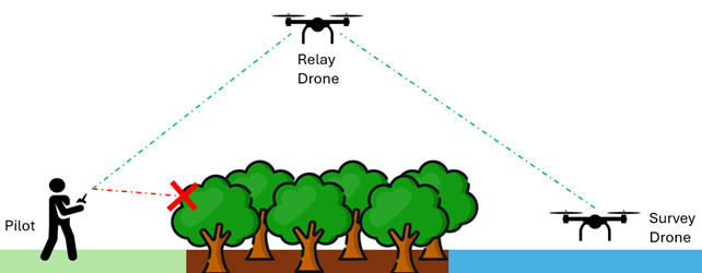
Conceptual illustration of the UAWOS BVLOS surveying setup
We are currently developing such a system, and we expect it to drastically improve efficiency during field operations. When flying in BVLOS, the survey drone would be able to perform several cross-section flights without requiring intermittent landings and crew relocations. As we have experienced in several of our field campaigns, reaching the riverbanks can be quite challenging and time-consuming, due to the lack of proper roads, as well as due to difficult terrain. We expect that by reducing these hindrances, a lot of time could be saved, and the duration of field campaigns could be shortened.
Due to the challenging nature of the river environment, and to ensure safe operation, we are also focused on developing robust localization algorithms, to ensure the drone’s position is always well known, and automated support systems, to detect obstacles and enable collision avoidance. We plan on applying for an official BVLOS permit to enable us to use this technology, and we look forward to deploying our BVLOS surveying workflow in an upcoming field campaign!
Impact Stories: Field work in Northern Sweden – Improving flood forecasts with UAS observations
In September last year, parts of the UAWOS team packed their gear and headed to Torne River in the north of Sweden, for a week of field work. The aim was to test new drone-based measurement techniques to collect hydrological data and explore how the new data can give input to improve flood forecasting models – partly combined with information from satellites. Ultimately, the goal is to provide better warnings and information on high flows and floods to society.
Drone data and satellite observations to improve models
The lead UAWOS partner for the Torne River case study was SMHI, the Swedish Meteorological and Hydrological Institute. SMHI is the governmental agency responsible for national provision of hydrological information to the society in Sweden. For this purpose, they engage in hydrological research and development, to maintain and improve the data collection and measurements needed for its operational flood forecasts and warning service.
“Forecasts require good quality data. At SMHI today, these come from a network of automatic stations and manual measurements. There is a strive to continuously improve our hydrological production chain and this is where UAWOS enters the picture. The data collection made possible with drones has the potential to fill certain data and knowledge gaps, refine calculations and further improve our models”, says David Gustafsson, project lead at SMHI.
For example, drones may gather information where manual measurements are not safe or accessible, e.g. in shallow or turbulent waters. They can also collect data continuously along river stretches, as opposed to the cross sections of standard manual measurements, by hydrometric stations. Drone data may further be used to transform satellite-based observations into river discharge data at previously unmonitored locations.
The field data collected in Torne River was on bathymetry, river water level, velocity and river discharge.
Torne river – a national river prone to floods
Torne river was chosen for several reasons. It is one of the few remaining non-regulated rivers in Sweden, without reservoirs, dams or hydropower installations. The river experiences a prominent spring flood which previously has caused flooding of housing, roads and infrastructure. In 2023, some areas faced the largest spring flood in over 50 years.
SMHI’s flood models for Torne River, used for the national warning service, have a lower performance than desired. Hence, there is a particular interest in improving model quality for the area.
“Complementary data from drones and satellites in these regions and beyond may help us provide even more accurate forecasts, which contributes to further strengthening society’s preparedness against flood events. ”We’re excited to be part of the project and explore these new methods further”, says Clara Greve Villaro, hydrologist in the forecast and warning service at SMHI.
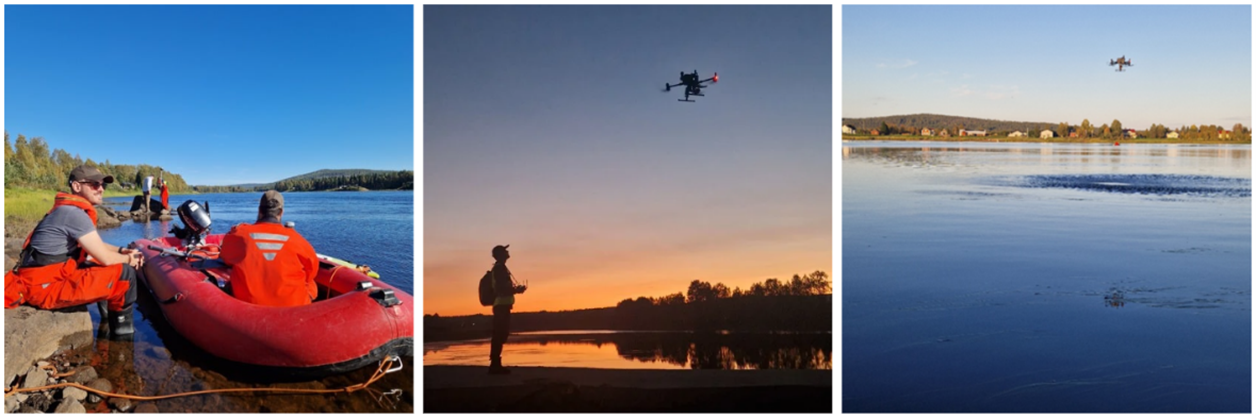
Field work in Torne river. Left: preparing manual measurements for validation of the drone data. Centre: eager researchers up after sunset. Right: drone measurements using a doppler radar. Photo David Gustafsson.